Coverage area maps created by TRAX application
Coverage area maps generated w/o consideration of local terrain?
This is an actual coverage area map created by TRAX. It shows a coverage area map for a West facing antenna located in downtown Colorado Springs, CO providing coverage area to most of Colorado Springs, North to the Air Force Academy, West to Woodland Park and Cripple Creek, and South down Highway 115 half way to Penrose, CO.
It appears TRAX does not take many factors into consideration when creating coverage area maps to include terrain. TRAX shows a cell tower located at an altitude of approximately 6,000 feet in Colorado Springs providing usable coverage area over a 14k high mountain (Pikes Peak) and back down to Cripple Creek at 9,500 feet and almost 20 miles away.
Inaccurate Coverage Area Maps
This coverage area map generated by the TRAX application shows a Southeastern facing antenna (panel), located in Cheyenne Wyoming providing coverage area for all of the city of Cheyenne, East to Nebraska, and South to Greeley Colorado including most of Fort Collins
The range of this antenna, according to TRAX is approximately 55 miles.
According to TRAX, a single cellular antenna could have a coverage area of up to 4000 square miles.
TRAX coverage area maps create false perception of mobile device’s location
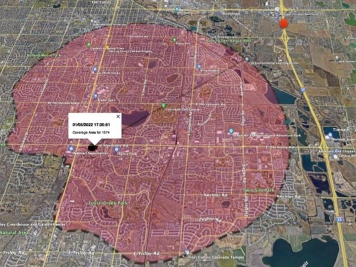
This map created by TRAX application shows a cell tower antenna coverage area suggesting the mobile device was located within the red shaded area. However, GPS data showed the device was over a mile outside the shaded area where the red dot is located.
NOTE: The TRAX application labeled the shaded area as “Coverage Area”


